
Powering the next generation ofEarth Observation
We integrate scientific research, custom optical sensors, artificial intelligence and mathematical data assimilation to transform Earth Observation into actionable intelligence.
Engineering Intelligence for Planetary Decisions.Earth Observation Should Not Be Limited By Fragmented Technology
Space programs and environmental authorities increasingly depend on Earth Observation over complex, data-scarce terrain—tropical mountains, rainforests, and mixed-emission corridors where validation data is thin and atmospheric dynamics are hard to model.
Unvalidated Orbital Products
Calibration & Validation Gaps
Limited in-situ reference data exists to ground-truth orbital products over complex tropical geography, creating high uncertainty in satellite observations.
Tropical Physics & Chemistry
Atmospheric Complexity
Complex micro-meteorology, steep Andean mountain valleys, and heavy tropical cloud cover cause off-the-shelf global models to produce severe prediction errors.
Disconnected Vendor Silos
Fragmented Stacks
Traditional space programs purchase optical hardware, GIS processing software, and predictive models from three isolated vendors that cannot exchange live telemetry.
One Integrated, Science-Grade System.
By owning capabilities across the entire Earth Observation value chain—from first-principles research and upstream optical sensor design to mathematical data assimilation and enterprise GIS software—we remove vendor silos and deliver uncompromised precision.
The Bee Ecosystem. Modular Space, Air & Ground Payloads.
Proprietary hardware devices engineered as multi-layer validation loops. Space, Stratosphere, Air, and Ground working together in synchronized environmental observation.
W-Bee®
A compact, ruggedized atmospheric monitoring unit designed for ground-level deployment, aerial platforms, and UAV integration.
WBee® measures 11 gas species at high temporal resolution alongside meteorological parameters, providing the most granular in-situ data available for airborne product ground-truth and atmospheric research.
Mathematics & Physics. Reducing Uncertainty in Complex Terrain.
HuMath combines first-principles mathematical models, atmospheric chemistry, and ensemble data assimilation to turn sparse sensor streams into continuous 4D predictive fields.
Multiple Sensors
In-situ gas sampling (W-Bee) + optical channels (K-Bee) + satellite radiometry.
Data Fusion
Geotagged alignment, noise filtering, and multi-spectral calibration loops.
Physical Models
Coupled WRF-Chem & LOTOS-EUROS chemical transport solvers.
Prediction
4D spatio-temporal chemical concentration fields & transport.
Decision Support
Automated risk alerts, policy compliance, & GIS layers.
WHERE MEASUREMENTS BECOME DECISIONS.
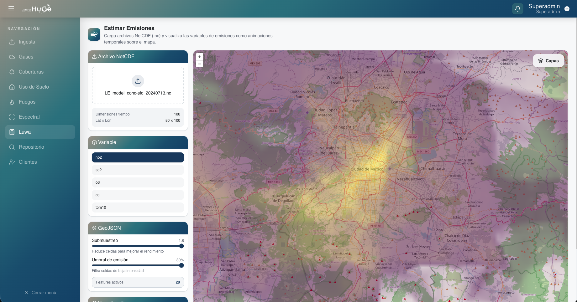
A digital platform that ingests raw telemetry from Bee devices and satellite passes, unifies data streams, and renders interactive spatio-temporal layers for rapid environmental decisions.

Active GIS Overlay Layer
Advanced environmental analysis and localized telemetry tracking.
GLOBAL VISION. BUILDING FOR INTERNATIONAL SPACE MISSIONS.
While founded on scientific excellence in Colombia, HuMath Space is built for global scale—developing technologies capable of supporting international satellite constellations and multi-agency environmental missions.
W-Bee & K-Bee Operational Standardization
Deployment across tropical Andes, Amazon basin, and polar expeditions (Antarctica) to collect ground-truth spectral and gas calibration datasets.
Custom Optical Space Payload Development
Engineering 3U/6U CubeSat optical instruments and beamsplitter systems optimized specifically for tropical cloud penetration and gas detection.
Global Multi-Sensor Constellations
Launching multi-satellite LEO networks integrated with ground-truth W-Bee hubs for real-time global environmental intelligence.
Designed for Multi-National Space Ecosystems
"By solving Earth Observation in the world's most complex atmospheric environments—tropical mountains and rainforest corridors—HuMath Space technologies deliver unmatched reliability anywhere on the planet."
PARTNERING ACROSS SCIENCE, GOVERNMENT & SPACE INDUSTRY




EXECUTIVE & SCIENTIFIC LEADERSHIP
Led by Ph.D. researchers, aerospace engineers, and systems mathematicians with decades of combined expertise in space technology and atmospheric data assimilation.

PhD. Olga Lucía Quintero
CEO & Co-founder
PhD. Olga Lucía Quintero
Mathematical Data Assimilation, Systems Engineering & Space Tech Strategy
Pioneer in mathematical data assimilation and system identification in Colombia. Professor at Universidad EAFIT and co-leader of Pink Tech Group, driving space tech innovation across Latin America.

Msc. David Restrepo
CTO & Co-founder
Msc. David Restrepo
Embedded Systems, Sensor Hardware Engineering & Aerospace Avionics
Expert in embedded hardware design and optics calibration for the Bee family of sensors. Directs upstream sensor research and CubeSat optical payload engineering.

PhD. Andrés Yarce
Data Assimilation & Emission Estimation Lead
PhD. Andrés Yarce
Atmospheric Chemistry, WRF-Chem & Inverse Modeling
Specializes in mathematical physics and inverse modeling of greenhouse emission plumes across industrial and rainforest corridors.

PhD. Álvaro Ochoa
Applied Physics Lead
PhD. Álvaro Ochoa
Radiative Transfer, Spectrometry & Atmospheric Optics
Leads optical sensor characterization and atmospheric radiative transfer models for ground and satellite optical channels.

PhD. Alejandro Madrid
Optical Developer
PhD. Alejandro Madrid
Multi-spectral Lenses, VIS+NIR Photonics & Sensor Design
Pioneer in custom optical assembly for lightweight remote sensing payloads and CubeSat optical instruments.

Msc. Sebastián Carmona
Partner Space & Co-founder
Msc. Sebastián Carmona
Orbital Mechanics & Space Mission Operations
Oversees Space Bee satellite architecture and international space mission partnership frameworks.

Melissa Acosta
Partner Health & Co-founder
Melissa Acosta
Environmental Health & Bio-meteorology
Bridges atmospheric gas concentrations with public health metrics and bio-meteorological indicators.

Lina Muñoz
Chief Financial Officer (CFO)
Lina Muñoz
Corporate Finance & Deep Tech Venture Growth
Manages financial architecture, global scaling operations, and institutional funding strategy.

Manuela Areiza
Chief of Software Development
Manuela Areiza
Cloud GIS Platform Architecture & Big Data Pipelines
Architect of HuMath Space Platform (HuGe), managing cloud-native GIS data streaming and real-time visualization.

Mariana Martínez
Product Engineer
Mariana Martínez
Hardware-Software Systems Integration
Directs physical prototype testing and flight payload integration for UAVs and stratospheric tests.
LET'S RUN A JOINT VALIDATION MISSION
Partner with HuMath Space to deploy ground-truth W-Bee units, airborne K-Bee optical flights, or co-develop custom satellite payloads for your mission.
Olga Lucía Quintero Montoya
CEO & Co-founder, HuMath Space
Mission Proposal Transmitted
Thank you. Our scientific mission operations team will review your parameters and respond within 24 hours.